
Introduction
And the regulation of the Ili river runoff by this reservoir significantly changed the landscapes of the delta, causing there, especially in the first decade, the degradation of vegetation, drying out and salinization of soils, and depletion of fauna.
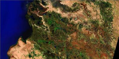
The filling and functioning of the Kapchagai reservoir on the Ili river in southeastern Kazakhstan (Fig. 1) over the course of 50 years has significantly influenced the coastal landscapes, in particular, the reclamation state of the soil cover (salinization and waterlogging of soils, active salt exchange of soils with reservoir’ water masses, the use of soils for irrigation, etc.), on the dynamics of the coastal vegetation as a fodder base for animal husbandry, on the conditions for recreation of the population, on the development of the local fauna and flora of the region.
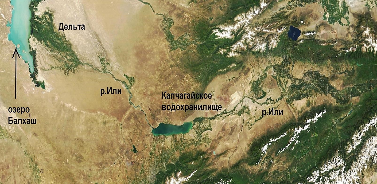 Fig. 1. Kapchagai reservoir on the Ili river (satellite Terra)
1. Formation of landscapes in the upper reaches of the reservoir
Quite unique landscape complexes are formed in the upper part of the reservoir as a new delta of the Ili River in the Kapchagai reservoir with an area of more than 20 thousand hectares. Annual accumulation of about 11 million tons. river sediments, as well as products of coastal abrasion and organic sediments lead to the formation of islands with hydromorphic landscapes. Increasing and uniting with each other, being re-formed by the water flow, overgrown with vegetation, they began to create land, which we called the “Kapchagai delta”. That is, hydrological and morphological processes occur here, leading to the formation of a delta-like object (Fig. 2), which we (with a degree of convention) typed as a “new (internal) delta” of the river (as in many large reservoirs in the world.
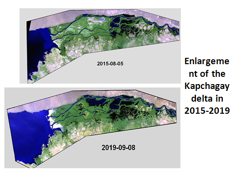
Fig. 2. Formation of the "Kapchagai delta" on the Ili river in the upper reaches of the reservoir
This process is uneven and depends on the variability of the water and solid flow of the river, fluctuations in the level of the reservoir and other factors. The average rate of increase in the area of the Kapchagai delta is more than 200 ha / year, but in high-water years, they can exceed 500 ha / year.
In accordance with the regularities of litho-morphogenesis and soil formation in deltas, a cellular relief is gradually formed there. In the upper part of the Kapchagai delta, islands of alluvial deposits are formed, overgrown with hydrophilic and hygrophilic vegetation. And with a gradual rise of the delta surface and an increase in backwater to the flow of water, the processes of horizontal migration of the main channel of the Ili River and the formation of channels (mainly from the southern side), destroying previously not flooded relatively high surfaces, intensify here.
In the middle part of the delta, extensive lacustrine-bog landscape complexes prevail, in which the inter-channel depressions are limited by slowly forming river-side ridges (“levees”) along the main channel (at the northern edge of the delta) and smaller channels along the entire width of this territory. The lakes are (in our opinion) of undoubted interest from the point of view of fish farming and fishing.
In the lower (western) part of the Kapchagai delta, the water runoff is concentrated in two large channels (Fig. 2) and a number of small channels, and the entire space from the northern to the southern coast is occupied by meadow-bog and bog complexes with predominantly reed and cattail vegetation, as well as small lakes. The cellular relief that is characteristic of typical deltas is still poorly developed here. The area of new alluvial deposits formation in the area of the “avandelta”, not yet overgrown with vegetation, is clearly distinguished (Fig. 3). The size of this area and its condition depends on the annual influx of river sediments and fluctuations in the level of the reservoir.
The processes of flooding and salinization of soils on the periphery of the Chilik fan, that is, at the contact with the Kapchagai delta, deserve special attention. They occur as a result of a gradual increase in the terrain due to the accumulation of mineral and organic sediments in this delta and, accordingly, an increase in the backwater flow of groundwater in the fan, directed from the mountains to the river.
The degree of soil hydromorphism here increases, the previously widespread meadow-serozem saline soils are transformed into “solonchaks” and meadow saline soils, and in the relief depressions, mainly meadow-bog and bog saline soils are formed (Fig. 4).
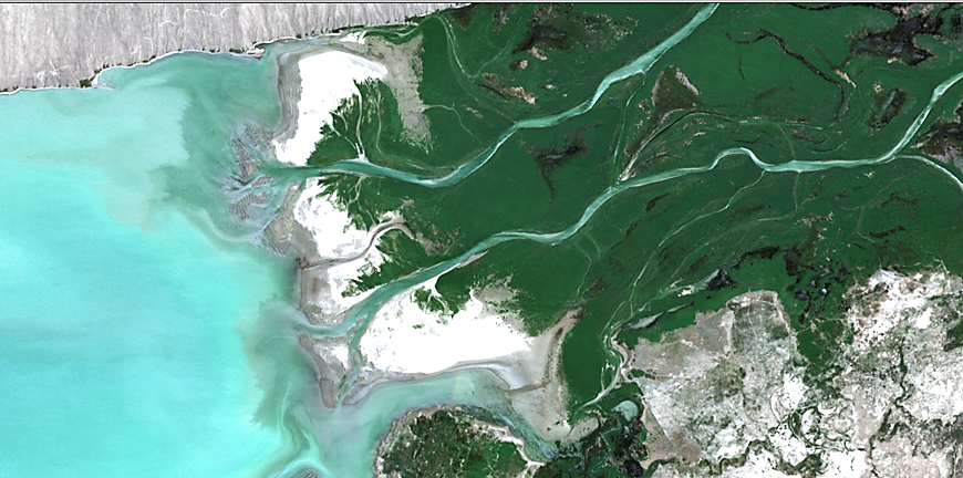
Fig. 3. Deposition of new alluvial sediments on the periphery of the Kapchagai delta (July 2020)
In the vegetation cover of semi-hydromorphic saline soils, a halohydrophytic group is widespread, including aeluropus and annual saltworts (seepweed, climacoptera, camphorosma, etc.). The vegetation of the hydromorphic soils of the relief depressions (reeds, etc.) is, nevertheless, a fodder base for local livestock raising.
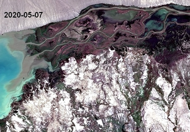
Fig. 4. Saline soils in the periphery of the Chilik alluvial fan at the contact with the newly formed delta
The formation of new hydromorphic landscape complexes (mainly lakes, wetlands, meadows) due to the backwater in the Ili river valley above the Kapchagai reservoir (from the former Ayakkalkan resort to the Charyn river mouth), as well as the discharge of water from the Charyn irrigation massif along the channel Karakaldek-Saryshagan, which are important as a fodder base for animal husbandry, objects of fishing and fish farming, nature conservation objects (Fig. 5), has an important significance.
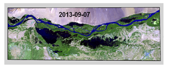
Fig. 5. Landscape complexes on the Ili River above the Kapchagai reservoir (image Landsat-8)
2. Zoning of the reservoir coast
According to the nature of the soil cover and vegetation, the southern coast of the reservoir is schematically divided into 4 regions (Fig. 6). The first area is the coast to the east from the high cape with the local name "Utyugi" to the new ("Kapchagai") delta. This is a low swampy and saline area with a width of up to 2-3 km, moistened with waterlogging by a reservoir, as well as by surface runoff of small channels in the western periphery of the Chilik fan. It is occupied mainly by meadow-boggy and meadow saline soils in combination with “solonchaks” (very saline soils); the vegetation is dominated by reed, azhrek (Aeluropus littoralis), and saltworts. It is used in local animal husbandry as fodder.
The second region is a vast rather flat plain about 50 km long from the “Utyugi” cape in the east to the village of Akzhal in the west, dissected only by the valleys of the Zharsu Rivers and especially - Turgen River. Directly on the coast, there is a strip up to 500 m wide with meadow crustal salt marshes, which are subject to periodic flooding by the reservoir when it is filled and then "depleted". The vegetation here is exclusively saltwort (salicornia, suaeda). Only in small shallow bays are areas of oppressed reed found. The content of soluble salts in soils is 1-2% or more, the type of salinization is sulfate-chloride and sodium chloride.
Further, a strip 2-2.5 km wide is occupied by meadow plump salt marshes, which are waterlogged by the reservoir. Over the past 30-40 years, this strip has not changed significantly, as evidenced by space images of Landsat-8 and Sentinel-2 (despite the "apocalyptic" forecasts of some researchers).
On the surface of these soils there is a plump layer of salts of 2-3 cm, their amount in the upper horizon is 2-4% or more. Salinity type is chloride-sulphate sodium with the participation of soda. Salt reserves in the 0-2 m soil layer reach 600-700 t / ha. The vegetation here is exclusively saltwort.
To the south (up to the "saz" strip at the contact between the plain and foothill strip), a vast area is occupied by ordinary salt marshes. The vegetation here is very sparse, represented by saltwort and tamarix bushes. The content of soluble salts in the profile of these soils is 1-3%; the presence of soda is often noted in the composition of salts. Salt reserves in the 0-1 m layer are 200-300 t / ha, and in the 0-2 m layer - 500-600 t / ha. Further to the south, these solonchaks are replaced by meadow-sierozem and meadow soils, often saline, of the so-called "saz" strip. The vegetation of virgin soils is meadows of Aeluropus littoralis, with increasing of soil salinity — chiy (Lasiagrostis splendens), licorice, wormwood, and saltwort appear. Higher in relief, these soils are usually irrigated. Along the river valleys that divide this relatively flat, slightly sloping plain, meadow, bog-meadow and meadow-boggy soils are formed, spreading from the shore of the reservoir to a distance of 3.5-4.5 km. These territories represent a fodder base for local livestock breeding, and are also used as hunting and nature conservation facilities.
In region 3, which occupies a coastal strip about 25 km long in the Issyk-Kaskelen interfluve, a strip of meadow soils up to 1.0-1.5 km wide is adjacent to the water's edge. The salt content in the 0-1 m layer ranges from 11-12 t / ha in non-saline soils to 50-75 t / ha in saline soils.
Often these soils are also alkaline. To the south, at a distance of up to 4-5 km from the coast, meadow-sierozem soils of the zone of secondary immersion of groundwater flowing from the mountains prevail. These ground waters occur at a depth of 3-5 m, fresh and slightly mineralized, with a satisfactory underground outflow. The plant cover is dominated by chiy (Lasiagrostis s.), licorice, camel thorn (Alhagi p.), small reeds, wormwood, bluegrass, and the chingil (Halimodendron h.) shrub is found. On saline meadow-sierozem soils, halophytic wormwood - camphorosma vegetation occurs. In terms of economic use, these are mainly pastures, in the southern part of the region there are irrigated arable soils.
To the northwest of the Kaskelen River mouth, a small area #4 with filtration lakes (due to waterlogging by the reservoir) and sandy islands is distributed. This region has no significant economic significance. On the northern coast of the Kapchagai reservoir, light sierozem soils (loamy and sandy loam) are distinguished to the west from the Sholak mountains to the Chingeldinsky irrigation massif inclusive, as well as gray-brown soils (often stony) - east of the Sholak mountains. In the westernmost part of the northern coast (in the modern recreation area), hilly sands are common.
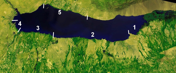
Fig. 6. Schematic zoning of the reservoir coast
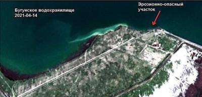
Waterlogging by the Kapchagai reservoir of soils on the northern coast is insignificant due to the features of the relief (sloping plain). It is important here to study irrigation erosion and the flow of waste water from irrigated fields together with agrochemists into the reservoir.
3. Processes of salt exchange on the coast of the reservoir
The study of the processes of salt exchange between soils and groundwater, on the one hand, and the water masses of the reservoir, on the other, seems to be very relevant. Studied for the first time back in the 70-80s, these processes significantly affect the hydrochemical regime of the reservoir and groundwater of the coast, as well as the salinity of soils that are waterlogged and periodically flooded by the reservoir every year during the periods of its cyclic filling and "depletion".
In the eastern and central parts of the coast (the Kaskelen - Issyk interfluve), as already noted, saline soils with a salt content of up to 200-300 t / ha in the 0-1 m layer and up to 500-600 t / ha in the 0-2 m layer and chloride-sulfate ionic composition with the participation of soda prevail. When these soils are waterlogged by the reservoir, that is, when the groundwater rises above 2 m, a powerful plump salt horizon is formed on the soil surface, and about 150-200 t / ha of salts additionally accumulate in the soils with an increase in the content of sodium chloride.
During the seasonal inundation (flooding) of these soils with surface waters (at the stage of filling the reservoir), they were usually desalinated to a depth of 0.5 m, and down the profile, salt leaching was only partial. In total, during the period of seasonal flooding, the leaching of salts from the 0-100 cm layer, according to our data, was about 260 t / ha. Thus, the leaching of salts during the flooding of 1 hectare of the coast, which had not previously been flooded, is about 260 t / ha from the 1 m soil layer. After lowering the reservoir level on the exposed surface with high salinity of groundwater, the restoration of soil salinity occurs extremely quickly (up to 170 t / ha in a layer of 1 m). Consequently, during the cyclical (annual) flooding of this part of the coast, from 170 to 260 t / ha of salts is leached out of the soil and enters the surface water.
The soils of the western part of the coast (the Issyk-Kaskelen interfluve) outside the zone of influence of the reservoir are mostly not saline or slightly saline, the salt content in the 1 m soil layer is about 25 t / ha.
When soils are waterlogged by the reservoir, the increase in the salt content in this layer is about 60-64 t / ha, that is, by the next flooding cycle, the soils are "enriched" with salts by this amount. And in the composition of salts, the amount of soda, toxic to vegetation, significantly increases. When soils are flooded, these salts are washed out by surface waters and serve as a source of increasing their mineralization and deteriorating ionic composition. Thus, with the cyclical annual flooding of this territory, about 64 t / ha of salts enter the surface water from each hectare of flooded soil.
The participation of groundwater in the feeding of the Kapchagai reservoir under the conditions of the Ili intermountain depression is beyond doubt. But by the time the reservoir was filled, the issues of the dynamics of groundwater mineralization (salt content) during waterlogging and flooding of the coast, as well as their role in salt exchange with soil and surface waters, had not been sufficiently studied. Therefore, at two sections (in the Chilik - Zharsu and Issyk - Kaskelen interfluve), studies of groundwater mineralization were carried out not only in the zones of periodic waterlogging and flooding by the reservoir, but also in the shallowest (up to 2 m) water area of the reservoir. In the Chilik - Zharsu interfluve, groundwater is highly mineralized (30-100 g / l), chloride and sulfate-chloride sodium. In wells 8 and 11 when filling the reservoir, the groundwater level rose from a depth of about 2 m to 0.1-0.2 m, and their mineralization remained at the level of 77-88 g / l. At the stage of "drawdown" of the reservoir level, the groundwater dropped again deeper than 1 m, but their mineralization remained the same. Consequently, when the reservoir is filled, there is no intense filtration of fresh water into the banks in this area, and no desalination of groundwater is observed.
The same result was confirmed when the coast was flooded with a water layer of 2-3 m for 5 years. In a specially equipped well R-11, the groundwater salinity remained at the level of 52-57 g / l. In the Issyk - Kaskelen interfluve, alkaline-type hydrocarbonate-sulphate magnesium-sodium groundwater is widespread. In the zone of periodic flooding by the reservoir, their initial mineralization is 4-6 g / l, when the surface is flooded, it decreases to 2-3 g / l, but with an increase in alkalinity from normal carbonates.
After the next decrease in the level of the reservoir and the release of this territory to the day surface, groundwater mineralization increases to 10-18 g / l, pH increases to 9.0-9.5, soda accumulates on the soil surface. In general, in this area, no intensive filtration of fresh water masses of the reservoir into the shores was found either, and after periodic flooding of the territory, soda formation is activated in the groundwater.
Indicators of the influence of soil salinity and groundwater salinity on the salt content in the reservoir water during the years of its filling were studied at the maximum level of the reservoir and the absence of wind mixing of water masses, as well as during periods of increase and depletion of the level.
Water samples taken at a 15 km section from the north to the south coast showed that the salinity of water near the north coast with non-saline soils was close to the salinity of river water (0.274 g / l) at that time. Towards the southern coast with saline soils and mineralized groundwater, the salt content in the reservoir water gradually increased and near the coast exceeded the salinity of river water by almost 2 times (Fig. 7). At the same time, the salinity of water in shallow reaches sometimes reached 1.320-3.504 g / l due to the dissolution of salts of flooded soils, but then decreased due to mixing of water masses to 0.4-0.6 g / l.
It is important to note that the flooding of the coastal saline soils is accompanied by a significant transformation of the ionic composition of surface waters in comparison with flooded soils. This is especially noted in the western part of the southern coast, where exchange processes lead to the formation of soda. Unique hydrochemical processes also occur in the area of the reservoir flooding the so-called "salt lakes" that formed on the piedmont plain in the Chilik - Zharsu interfluve as a result of wedging out of saline ground waters. In these lakes, brines of sulphate-chloride sodium composition with mineralization up to 120 g / l were formed. During the flooding of this territory, the salt masses accumulated in the lakes entered the surface waters of the reservoir as the hydrological connection with the reservoir increased. When the area of lakes became a reservoir bay, the salinity of water decreased to 18-19 g / l, and then, with wind mixing, it gradually decreased to 6-7 g / l. Over the next 3 years, with a rise in the level of the reservoir, "transformation" of the banks and increased wind mixing of water masses, water salinity gradually decreased to 1, 1 g / l. And only when this territory became an open water surface, the salinity of water decreased to the values typical for the southern coast of 0.5-0.6 g / l. Consequently, the leaching of salts from saline soils of the flooded coast and the inflow of saline groundwater are important sources of an increase in the salinity of the water in this reservoir.
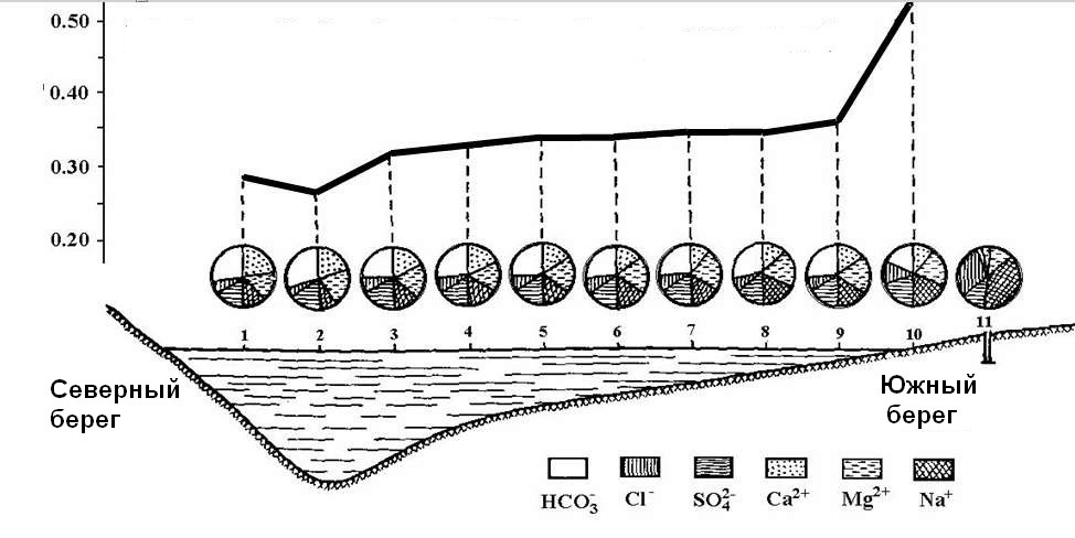 Fig. 7. Transverse hydrochemical profile of the reservoir (g / l) and cyclograms of the ionic composition of water
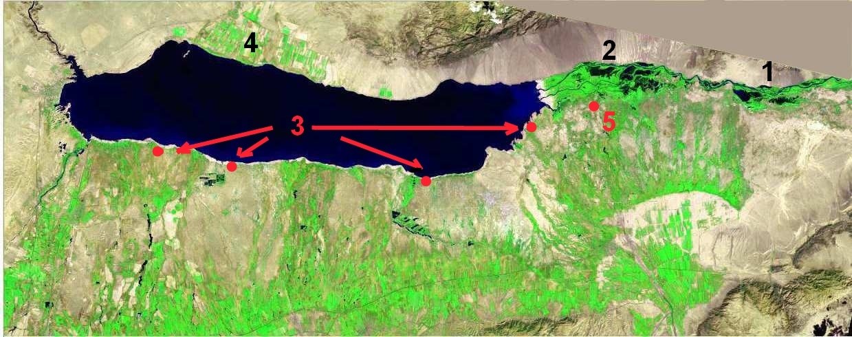 Fig. 8. Recommended objects for research: 1 - new wetlands above the reservoir, 2 - Kapchagai delta, 3, 5 - points for studying soil salinization processes, 4 - Chingeldinsky massif
To continue studies of the dynamics of salts in soils, ground and surface waters, taking into account the results we have accumulated, 5 points are recommended, shown in Fig. 8. Of particular interest for the study of the hydrochemistry of the Kapchagai reservoir is the wastewater runoff from the Chingeldinsky irrigation massif on the northern coast.
Conclusions
The creation of a large Kapchagai reservoir in the Ili intermountain depression for the purposes of energy, irrigation, recreation and fish farming has led to significant changes in the natural environment on its coast and in the reservoir itself. These are, first of all, waterlogging and salinization of coastal soils; the formation of new wetlands in the reservoir itself ("Kapchagai delta"), as well as above the reservoir; activation of salt exchange between coastal soils and water masses with an increase in the salinity of the reservoir water; waterlogging of a part of the city of Kapchagai, etc. The dynamism of these consequences of the reservoir creation requires long-term monitoring and forecasting of negative environmental consequences, especially waterlogging and salinization of the southern coast, with the aim of the most efficient natural resources use and protection. It is extremely important to consider the Kapchagai reservoir as a strategic water resource in this part of Kazakhstan, taking into account the increase in water consumption in the Chinese part of the river basin, climate changes, as well as the creation of a large Ili-Balkhash nature reserve. For optimal watering of this reserve, we consider it expedient to construct a counter-regulator for the flow of the Ili River in its lower reaches.


Обсуждение